hiti

Streamflow monitoring in the Hanumante Watershed

Streamflow monitoring in the Hanumante Watershed

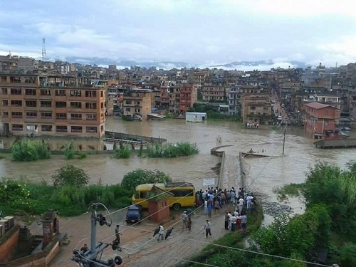
Flooding is regarded as one of the critical concerns in urban areas of Nepal, especially Kathmandu Valley (KV). The frequency of urban flooding in the KV has increased dramatically over the recent years owing to abrupt population growth, and unplanned urbanization (World Bank, 2017). Apart from that, river pollution is widely prevalent in the KV, which has ultimately affected the urban ecology of the streams.  Among the different tributaries of the Bagmati river in the KV, the Hanumante river is highly prone to urban flooding, and water pollution. Although the river has several cultural/irrigational significance (Shrestha 2007; Sada, 2012) and its upstream is a critical source of water to the inhabitants, the river has become tremendously stressed in recent years. The river has experienced the two largest incidents of flooding in the last decade (2015 and 2018), which had several detrimental impacts. 


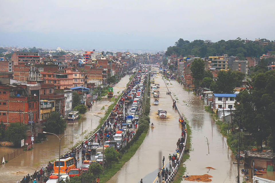
Figure 1: Flooding Hanumante Watershed in 2015 (left) and 2018 (right).

Furthermore, the flood risk seems to be emerging with each passing year. This can be attributed to the encroachment of the floodplains for settlement purposes and the government lags for developing/implementing proper land use policy (Prajapati, 2018). The direct discharge of untreated household sewage and industrial effluents, pesticides from agricultural runoff has led the Hanumante river to be severely polluted. These two critical issues of the Hanumante river have posed significant socio-economic challenges/impacts in the livelihood of the people living nearby; majorly by the inundation of the agricultural and settlement area, health hazards associated with pollution of the river, and so on. As such, proper hydrometeorological data are crucial to understand the flood dynamics, propose effective mitigation measures to the associated stakeholders/policymakers, and manage the river in a sustainable manner. There are already four rainfall stations installed by the Department of Hydrology and Meteorology (DHM) in different places of the Hanumante Watershed (Changunarayan, Nangkhel, Nagarkot and Suryabinayak). However, much effort has not been made in the last decade to collect the water level/streamflow/quality data of the Hanumante river. 

Figure 1: A map of the study area (Hanumante watershed) showing monitoring sites (red dots).

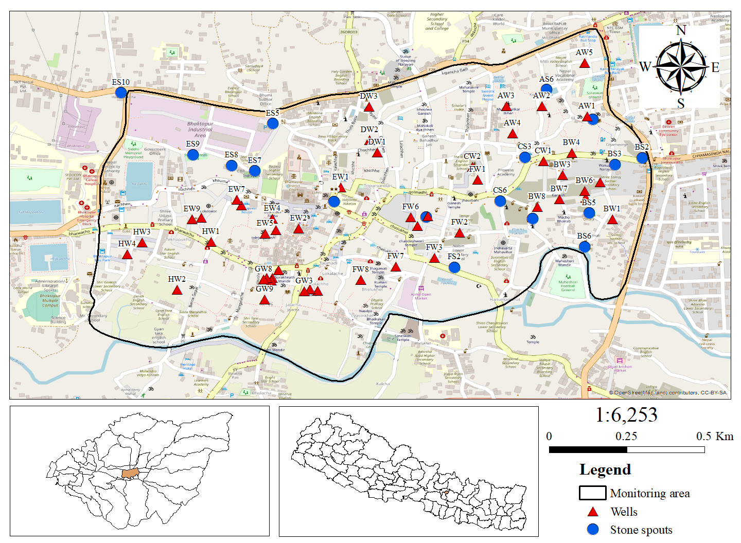
Realizing the need for hydrological monitoring in the Hanumante Watershed, Smartphones For Water (S4W-Nepal) has been gathering hydro-meteorological data of the Hanumante river since 2019 with the help of Citizen Scientists (CS) and young researchers. S4W-Nepal has been monitoring the stream water level using staff gauges, and bimonthly stream discharge using Acoustic Doppler Velocimeter at the 12 different sites of the Hanumante river (Figure 1). Along with that, S4W-Nepal has been collecting a few physicochemical water quality parameters such as temperature, pH, Electrical Conductivity (EC), Total Dissolved Solids (TDS), and dissolved oxygen using respective portable water quality meters. Besides, S4W-Nepal in collaboration with the High Powered Committee for Integrated Development of Bagmati Civilization (HPCIDBC) have been monitoring the important water quality parameters, including pH, Turbidity, Total Suspended Solids (TSS), Biological Oxygen Demand (BOD), Chemical Oxygen Demand (COD), Fecal coliform, and total phosphate) from nine different sites of Hanumante river. 

Figure 2: Map showing seasonal discharge (m3/s) in the 12 different sites of the Hanumante river in i) Pre-monsoon, ii) Monsoon, iii) Post-monsoon and, iv) Winter  (2019 to 2021).

Hanumante Watershed receives 80% of total annual rainfall within the monsoon season i.e., June-September. The seasonal variation of streamflow in the Hanumante river from 2019 to 2021 is clearly presented in Figure 2. It is evident that the streamflow in the Hanumante river is majorly dependent upon monsoonal rainfall. The discharge of all three major tributaries is less than 0.2 m3/s in all seasons, which increases to 1.2 m3/s or more after the confluence in monsoon and post-monsoon seasons. However, during pre-monsoon and winter, the discharge of the stream remains moreover constant i.e., less than 0.4 m3/s from upstream to downstream, which is likely due to the insignificant rainfall, extraction of water for irrigation and construction purposes, and groundwater percolation (Wang, 2013). Besides, a recent study has suggested that the estimated return period of the water level of about 3.5m in the Hanumante river is ten years (Kindermaan, 2020).

As per the recent data by HPCIDBC at nine different sites, the overall water quality of Hanumante river in post-monsoon of 2021 was found to be adversely degraded. It was found that the water quality parameters for the majority of sites exceeded the National Water Quality Guidelines for Irrigation Water/Aquaculture. This suggests that the water quality of the Hanumante is not suitable for the irrigational purposes and aquaculture. Further, the sites located in the dense settlement areas of the Bhaktapur district (downstream of Hanumante river) were found to be highly polluted, which might be due to the multiple anthropogenic influences. 

In the coming days, S4W-Nepal intends to continue monitoring the streamflow, water level, and quality even more intensely and generate some meaningful inferences/information, which will support the management of Hanumante river. The regular monitoring of Hanumante river is crucial to determine flood frequency, return level and maximum flood level, which can assist in designing flood mitigation plans, and reducing the dreadful impacts of flooding Moreover, local government/organizations, academic institutions, and responsible authorities should work together with specific goals and plans for better management of the river. The management of the river in a sustainable manner along with local participation should be the utmost priority of all the concerned stakeholders. 

References

Kindermann, P.E., Brouwer, W.S., van Hamel, A., van Haren, M., Verboeket, R.P., Nane, G.F., Lakhe, H., Prajapati, R. and Davids, J.C.\ (2020) Return level analysis of the hanumante river using structured expert judgment: A reconstruction of historical water levels. Water, 12(11), pp.3229. Available from DOI: https://doi.org/10.3390/w12113229 

Prajapati, R., Raj Thapa, B. and Talchabhadel, R (2018) What flooded Bhaktapur? My Republica, 17 July 2018.

Sada, R. (2012) Hanumante River: Emerging uses, competition and implications. Journal of Science and Engineering, 1, pp.17-24.

Wang, S.Y., Yoon, J.H., Gillies, R.R. and Cho, C. (2013) What caused the winter drought in western Nepal during recent years?. Journal of Climate, 26(21), pp.8241-8256.

World Bank (2017) Land Use Planning for Urban Flood Risk Management. Urban Floods Community of Practice Knowledge Notes. The World Bank, 2017.

Streamflow monitoring in the Hanumante Watershed Read More »

Traditional hiti system of the Kathmandu Valley

Traditional hiti system of the Kathmandu Valley

The hiti system is the cornerstone of the ancient water management system in the Kathmandu Valley, Nepal. The hiti system was introduced in the Valley even before the Lichhavi period (400-750 A.D.), and its network was expanded during the Malla period (Shrestha and Maharjan, 2016). A hiti (stone spout in English) is a traditional water resource usually present at a man-made depression in which water is channeled from a source to function as a tap. The traditional hiti system is an integrated water supply system that incorporates major sources of water i.e., rainwater, groundwater, and surface water resources. The hiti system consists of five major components:

Figure 1: Flowchart showing the working of the traditional water supply system.

  1. Intake 
  2. The conveyance canals and the rajkulos
  3. The stone spouts or the hiti 
  4. The pukhus and wells
  5. The drainage system / 

This traditional water system has served as one of the vital water sources required to meet water demands during dry days since ancient times. It is still actively used for drinking purposes by the locals residing in some core areas of the Valley. Recent studies have shown that the existing stone spouts of the Valley have been contributing to fulfill the water demands of about 10% of its population (Tripathi et al., 2019). Besides its significance in terms of water supply, the hiti system possesses considerable historical and cultural importance. However, the system has not been valued and often neglected by both the community and the state after the introduction of the modern piped supply system in 1950 A.D. (UN-HABITAT, 2008). At present, the traditional water supply systems (stone spouts, ponds, and wells) are in defunct conditions owing to the weak management capabilities of the government, the absence of proper policies, and lack of ownership. According to the Kathmandu Valley Water Supply Management Board (KVWSMB) report, there are 573 stone spouts and 233 ponds in the Valley, out of which 94 stone spouts and 40 ponds are completely lost (KVWSMB, 2019). Therefore, the existing traditional hiti system and its components should be monitored, conserved, and actions should be taken for the revival of the system.

Figure 2: Study area showing the location of monitoring wells and stone spouts.

Smartphones For Water Nepal (S4W-Nepal) has been monitoring the traditional hiti system of the Bhaktapur Municipality (BM) through a feasible citizen science approach. In order to monitor the hiti system of the BM, S4W-Nepal has recruited and trained 13 Citizen Scientists (CS) who are currently pursuing their bachelors. The CS have been recording monthly data of the discharge/quality of 16 stone spouts and the groundwater level/quality of 49 wells since 2019. Based on the collected data, S4W-Nepal aims to study the water distribution mechanism, the interactions of the stone spout with the neighboring wells and ponds, and also initiate the study on the possibilities of the revival of the system. Figure 2 shows the locations of the monitoring wells and stone spouts of S4W-Nepal. In the mid of every month, our CS measure the groundwater level using a measuring tape, and stone spout discharge by the help of a measuring cylinder. The stone spout discharge is calculated by determining the volume of water filled in the measuring cylinder within a certain period of time. Certain water quality parameters including temperature and Electrical Conductivity (EC) are also monitored using the HoneForest EC meter. An android application called Open Data Kit (ODK) Collect was used as a data collection platform.

Seasonal variation of groundwater levels and stone spouts discharge 

A preliminary analysis has been carried out considering the monthly groundwater level and stone spouts discharge data collected by our CS from March 2019 to February 2021. The monthly data was transformed into seasonal data to understand the seasonal variation.

Figure 3: Boxplot showing the seasonal variation of groundwater level from March 2019 to February 2021

Figure 4: Boxplot showing the seasonal variation of stone spouts discharge from March 2019 to February 2021.

The boxplots (Figure 3 and 4) show the seasonal fluctuation of the groundwater level and stone spouts discharge in the period of two years (March 2019 to February 2021). The groundwater level was maximum during the pre-monsoon in both 2019 and 2020 and lowest during the post-monsoon in 2019 and monsoon in 2020. Similarly, the discharge was observed to be highest during the monsoon season in 2019 and post-monsoon in 2020. Over the study period, the discharge was lowest during the pre-monsoon season, followed by winter. However, it was found that the overall discharge of the stone spout in all four seasons was higher in 2020/2021 compared to 2019/2020. The higher precipitation in 2020 compared to 2019 is the possible cause for such variation in the groundwater level and stone spout discharge in the two years. The overall seasonal trend in the fluctuation of the groundwater level and stone spouts in both years was almost similar, indicating high dependence of the groundwater level and water discharge on rainfall. As the trend is similar in both boxplots, it can be assumed that there exists a certain degree of interactions between stone spouts and wells of the BM.

Interactions between stone spouts and wells in terms of EC

Figure 5: Spatial variation of EC in the stone spouts and wells during monsoon 2019/2020
Figure 6: Spatial variation of ECin the stone spouts and wells during post-monsoon 2020/2021

The parametric values of EC recorded by our CS in the two years were analyzed to understand the interactions of the wells and stone spouts. The above map (Figure 5) shows the spatial variations of EC in the stone spouts and wells of the BM. It can be observed that the well AW1 and stone spout BS3 lie nearer to each other and their EC values were also similar. Similarly, the stone spout CS3 and the wells CW1 and BW4 had close EC values. Furthermore, the stone spout CS5 and the well BW8 showed almost the same EC values. So, the aforementioned stone spouts and wells were found to interact in terms of EC and may have the same source. However, any strong conclusion can’t be drawn on the basis of this finding, since only one parameter was taken into account.

Furthermore, similar studies including multiple water quality parameters along with proper site selections should be carried out to fully comprehend the interactions between stone spouts and wells. The traditional hiti system is a very unique water heritage with great architectural and cultural significance and can serve as an excellent source of drinking water, particularly in the water-scarce region like the Valley. The degradation of traditional water resources not only causes a water supply deficit but also poses a significant influence on the historical and traditional aspects of the Valley. Therefore, the conservation and preservation of the existing traditional hiti system should be promoted and studies related to the feasibility for the revival of their components should also be initiated by the concerned authorities and organizations.

Reference

Shrestha, R.P. and Maharjan, K.L. (2016) Traditional water resource use and adaptation efforts in Nepal. Journal of International Development and Cooperation, 22(1&2), pp.47-58. Available from URL: https://core.ac.uk/download/pdf/222955771.pdf [Accessed 12th May 2021]

Tripathi, M., Hughey, K. F. D. and Rennie, H. G. (2019) The State of Traditional Stone Spouts in Relation to Their Use and Management in Kathmandu Valley, Nepal. Conservation and Management of Archaeological Sites. 20 (5-6), pp 319-339. Available from URL:  https://www.tandfonline.com/doi/abs/10.1080/13505033.2018.1559421  [Accessed 12th May 2021]

UN-Habitat (2008) Water Movement in Patan: With Reference to Traditional Stone Spouts in Nepal. United Nations Information Centre, Kathmandu Nepal: United Nations Human Settlements Programme.Kathmandu Valley Water Supply Management Board, Government of Nepal (2019). Stone spouts and ponds of Kathmandu Valley. Kathmandu, Nepal: Government of Nepal, Ministry of Water Supply and Kathmandu Valley Water Supply Management Board.

Traditional hiti system of the Kathmandu Valley Read More »