
Monsoon in Nepal
Rocky Talchabhadel
Researcher, Kyoto University
Board Member, S4W-Nepal
The word “Monsoon” comes from the Arabic word “mausim” which translates directly to ‘season’ in English. The monsoon season in Nepal and other parts of Central and Southeast Asia is characterized by a large seasonal shift in wind flow and direction accompanied by a dramatic increase in precipitation. Monsoon can be both boon and bane for inhabitants of this region. Extreme (heavy) precipitation during the monsoon season often results in major water-induced hazards such as floods, landslides, and debris flow. However, the monsoon season is equally important for agriculture and the economy. Lower than average monsoon precipitation, or even simply a later than average start date to the monsoon season, can have a disastrous impact on the nearly 3/4th of the population in Nepal that is dependent on agriculture. The nature of the monsoon precipitation – its amount, temporal variability, intensity, frequency of occurrence, and spatial variation is a major factor affecting agricultural potential. In Nepal between 1968 and the present, the average start and end dates for the summer monsoon are June 10th and September 23rd, respectively. Figure 1 shows the start and end dates, and average duration, during this period.
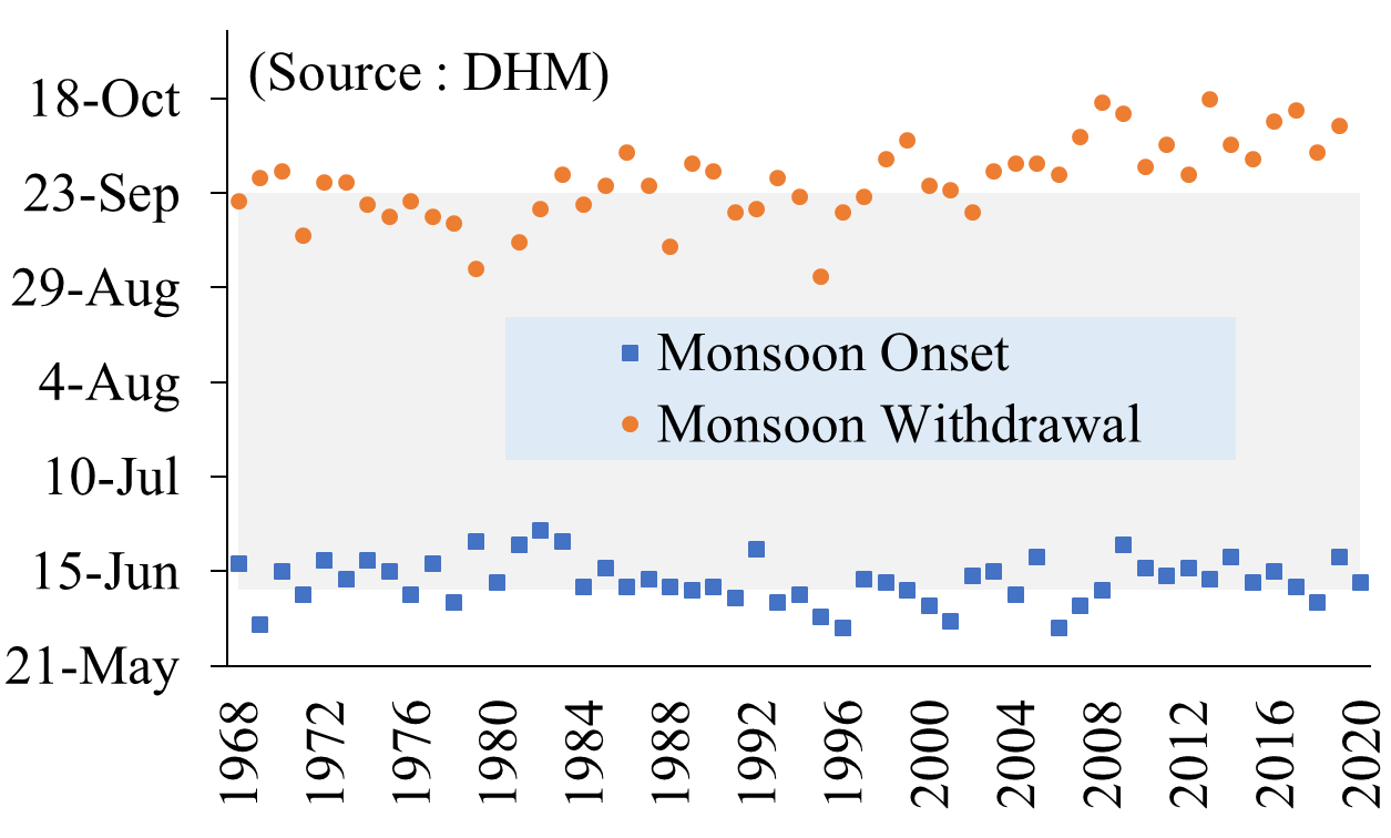
The country receives more than 80% of its annual precipitation during the monsoon season (Shrestha, 2000). Rice is a major food staple in Nepal. The planting of rice normally begins in early May in the hills and in June in the Tarai, the country’s food basket. The monsoon precipitation is directly linked with the growth of this rice crop and the country’s agriculture and in turn, the economy. This year (A.D. 2020) monsoon began in Nepal on the 12th of June. The monsoon season is characterized by not continuous but continual rain for a few days separated by rainless intervals. The long term temporal record of monsoon onset and withdrawal (Figure 1) shows a delayed monsoon withdrawal coupled with either altered or unchanged monsoon onset. The monsoon season is, in general, found to be longer in recent times. On average, six or seven monsoon depressions* (twice per month) move in every year, each corresponding to a period of about 17 days (Nayava, 1980). When the monsoon trough (a large depression) moves closer towards the foothills of Nepal (which we call active break-monsoon), heavy precipitation-related extreme events usually occur in parts, or across the whole, of Nepal. During such extreme precipitation events, floods (river floods, flash floods, urban floods) are likely to occur. The timing of flood/inundation and early warning mechanisms are crucial for effective mitigation of flood risks, along with mapping and understanding of flood-prone areas, which are, to some extent, predictable.
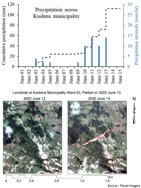
However, landslides and debris flow can sometimes even occur in unexpected areas. A recent example of a landslide followed by a debris flow at Kushma municipality, Parbat on June 13, 2020 highlights this point. The terrain, which never experienced a landslide before, experienced this, followed by a debris flow that was a devastating event affecting lives and property. Figure 2 shows a preliminary assessment of cumulative precipitation derived from hourly precipitation data of a satellite-based product, PERSIANN CCS (spatial resolution, 4 km) and the spatial location of landslide/debris flow before and after the event using Planet Imagery (spatial resolution, 3 m).
Even a single event with intense precipitation for a short period can bring urban inundation, land/mudslides, or flash flooding. Therefore, it is high time to map potential hazards and prepare for worst-case scenarios. You can’t manage what you don’t measure. Citizen-science based precipitation measurements can be used as a reference to calibrate and correct satellite-based precipitation estimates. Let’s measure.
Reference:
Nayava JL. 1980. Rainfall in Nepal. The Himalayan Review. Nepal Geological Society, 12.
Shrestha ML. 2000. Interannual variation of summer monsoon rainfall over Nepal and its relation to Southern Oscillation Index. Meteorology and Atmospheric Physics, 75: 21–28. https://doi.org/10.1007/s007030070012.
*Note: Monsoon depression: a depression that forms within the locations of relatively minimum sea level pressure in a monsoon region.