Water Induced Disaster In Nepal And The Role Of Citizen Scientist
Dinesh Pathak
Central Department of Geology, Tribhuvan University
Kirtipur, Kathmandu, Nepal
Email: dpathaktu@gmail.com
Dinesh Pathak
Central Department of Geology, Tribhuvan University
Kirtipur, Kathmandu, Nepal
Email: dpathaktu@gmail.com

Abstract
This article focuses on the water-induced disaster (landslide and flood) conditions in Nepal. It analyzesThe past and present water-induced disaster conditions in the country haves been analyzed, the importance and means for creation of the database have been explored, identifies data gaps in water induced-disaster mitigation have been identified, explores the importance and means for creation of a database to house and organize data, visualizes the role of citizen scientists in data generation was visualized, and describes the efforts to date of S4W-Nepal there have been signified and described.
Introduction
The Himalayan region represents an active tectonic zone, and about 35% of the Himalayan belt lies in Nepal. The 147,515 km2 territory of Nepal can be divided into three main geographical regions; the Himalayan region covers 15% of the total area, the hilly region covers 68%, and Terai, also known as the food basket of the country covers 17% of the total area. The Himalayan terrain is formed by the complex geological process, which is still continuing to shape the Himalayan region. Such geological activities together with the hydrometeorological process have caused various types of hazards that eventually pose vulnerability to people, infrastructure, and natural resources. Thus, the larger population in the region has been exposed to multi-hazards, like earthquakes, landslides, soil degradation, flood, deforestation, loss of biodiversity, and drought.
Water-borne disasters like landslides, floods, soil erosion are common during the monsoon period in the entire Himalayan region. Snow avalanches are common, and glacial lake outbursts occasionally occur in the Himalayan region. These disasters have a significant impact on the natural system, settlements, and infrastructure in Nepal. In the past decades, climate change has been observed worldwide. For the future, predictions indicate average temperature rise, change in precipitation patterns in space and time, melting glaciers, sea-level rise, etc. with a large band of uncertainty. Likewise, extreme drought, intense rainfall, severe flood events, etc. are also predicted to occur more often under climate change conditions.
Different aspects of disasters like a landslide, dam outburst flood, the occurrence of landslides due to bank erosion by the river and slope instability, floods, and infrastructure failure causing landslides and floods, etc. are different sorts of water-induced disasters. Himalaya is extremely vulnerable to natural disasters due to its geology, steep slopes, high relief, and monsoon climates and among the different natural disasters, landslides are important geological events in many parts of the world (Pathak, 2016a).
Effect of past water induced disaster in the country
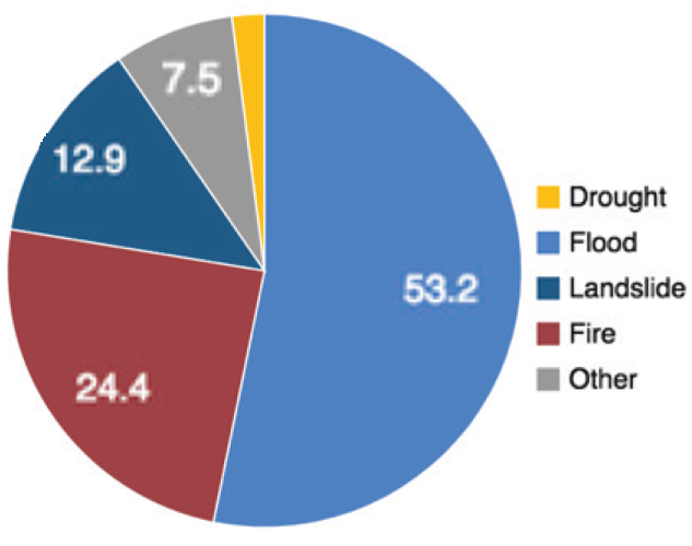
Water induced disasters (Landslide and flood disaster) have greater and regular impacts among all other disasters, which is evident from the highest mortality (66%) for the period between 1990 and 2014 (Figure 1).
Several events of water-induced disasters have increased the number of deaths, displacement of large numbers of families with damages to thousands of houses. It is quite convincing that these disasters are the major disasters in the country with an eminent impact on the people. Nevertheless, the earthquake disaster has a much greater and long term impact on all sectors of life even though it happens in a longer time interval. Even a single earthquake event can have more death, destruction of houses and infrastructure, as well as greater economic losses than the total due to other disasters in several decades.
The water induced disaster
Landslide and debris flow
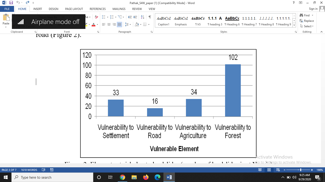
Landslides are common in all physiographic regions of Nepal, i.e. from the Chure range in the south to the Higher Himalayan region in the north. The analysis of landslide data in different regions of Nepal shows that in general, most of the landslides have occurred in elevation class between 500 m and 2000 m. Physiographically, landslide occurrence is more in Middle Mountain and High Mountain regions. Likewise, the topographic slope is another important factor for the occurrence of landslides, and the slope angle between 20 and 40 degrees is most sensitive for the landslide occurrence. Geologically, most slope instability issues are in Siwalik and Lesser Himalayan regions. Generally, we believe that the vegetation-covered areas are the stable ground; in contrast, the analysis of the data shows that in most of the cases, landslides occur in the forest area. It indicates that the vegetation is effective to provide ground stability only against the shallow slope failure, while for the deep-seated failure plane, especially below the root zone of the vegetation, large scale landslides may occur with significant damages to the forest land that may impose risks to other elements like settlement, agriculture land, and infrastructure at the downslope. An analysis of landslide vulnerability in eastern Nepal shows that many landslides have increased vulnerability to forest followed by agriculture, settlement, and road (Figure 2).
Google Earth’s image is useful for the rapid assessment of landslides in an area, and it is especially useful in the identification of large and disastrous landslides (Figure 3). Likewise, it is quite helpful to identify the earthquake-induced landslides through comparison between the images before and after an earthquake (Figure 4). Either a new landslide can be developed or the old inactive landslide could be triggered during an earthquake.
Figure 3: Landslide in (a) Okhaldhunga district located at Manebhanjyang Gaupalika; and (b) Sankhuwasabha district at Makalu Gaupalika
Figure 4: Damage to road from earthquake due to triggering of the old landslide as well as the development of a new landslide in Dhading (left image before the earthquake and right image after the earthquake)
Flood
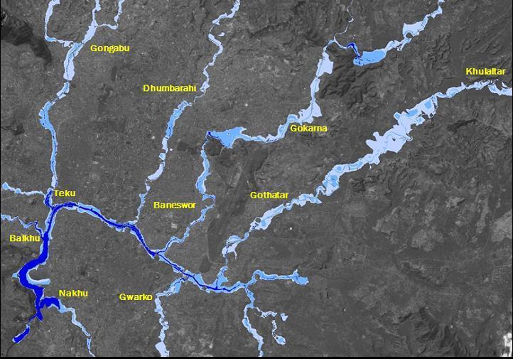
Flood is a common hazard that sometimes becomes a disastrous event due to its magnitude and presence of a large number of vulnerable elements. Such events are occurring both in the mountainous regions as well as in the Plain area. The rivers flowing through the Kathmandu valley have been heavily stressed due to encroachment as a result of urbanization. The natural regimes of the rivers are not maintained to the required waterway and also the natural regime of the river is much affected. This is the reason that many regions in the Kathmandu Valley are experiencing flood problems in each monsoon period. The flood hazard map of the Kathmandu Valley shows that both the urban core areas, as well as newly urbanized areas are prone to flood problems (Figure 5).
Gaps in water induced disaster mitigation
In order to address the growing vulnerability due to the water-induced disaster, proper understanding of the biophysical, social, and institutional components is required. The water-induced disaster mitigation (WIDM) has been given the prime importance from the government of Nepal, however, a mounting disaster-induced loss indicates that disaster risk reduction is far from getting its due share of attention and resources (Pathak 2016b). Lack of seriousness and accountability of the decision-making authority, unavailability of the adequate database, low priority, and insufficient fund allocation for the disaster related study are some of the issues related to the inefficiency of disaster mitigation. Pathak (2016c) has pointed out some of the important measures to be considered for effective water-induced disaster management, which are listed below:
- A hazard map is not adequate for planning rather risk map is more useful
- A comprehensive disaster database will be supportive for disaster management
- Prioritization of the watershed based on the water-induced disaster will facilitate effective disaster management
- Regular monitoring and effective early warning system will reduce disaster loss
- Institutional strengthening with effective coordination and networking among government line agencies
- I/NGO should be given appropriate roles to work in coordination with the government in a supportive role. These organizations should work on various sectors as identified and prioritized by the government
- Get prepared for the worst
Conclusion
Landslide and debris flow, as well as floods, are the major water-induced disasters in Nepal. There are many stakeholders for effective disaster management, namely government, non-government organization, disaster experts as well as the local residents. The role and activities of those stakeholders are almost defined, however, the role of local residents is least brought to the mainstream of disaster management. Data required for disaster management are available on national, provincial, and district level. However, there is a scarcity of data (like precipitation and flood discharge) at the local level, especially at the community level. These data are required to assess the disaster condition and to develop models required for disaster management. The local residents can be trained and given the responsibility to measure the hydrometeorological data so that a comprehensive database can be formed at the community level. Besides, these citizen scientists can act as valuable messengers to the community regarding community awareness in disaster management. S4W-Nepal has realised the importance of citizen science and its activities are focused to bridge the gap.
References
Pathak D, 2016a. Knowledge based landslide susceptibility mapping in the Himalayas. Geoenvironmental Disasters (2016) 3:8, DOI 10.1186/s40677-016-0042-0
Pathak D, 2016b. Water Induced Disaster Mitigation from Watershed Management Perspective in Nepal – An Example from Dobhan Khola Watershed, West Nepal. International journal of landslide and environment, vol. 4(1-3), 9-19.
Pathak D, 2016c. Water induced disaster mitigation in Nepal – present approach and way forward for effective water induced disaster mitigation from geological perspective. Disaster Review 2015, pp. 25-30.
Pathak D, Gajurel AP, Dwivedi SK, Shreshta GB, 2009. Flood risk mapping in urban area using high resolution satellite imageries. Proceedings of international seminar on hazard management for sustainable development, 29-30 Nov, 2009, Kathmandu, Nepal, (organized by Department of Water Induced Disaster Prevention, Nepal Engineering College and Ehime University). Eds. H.K. Shrestha, R. Yatabe and N.P. Bhandary, pp. 233-244.
UNISDR, 2015. Global Assessment Report on Disaster Risk Reduction 2015: Nepal. UNISDR
Note: ‘Young Researcher’ Issue 3 – Sept 2020
Water Induced Disaster In Nepal And The Role Of Citizen Scientist Read More »