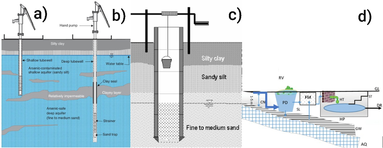
Groundwater, the water present in the spaces between rock and soil particles of the saturated zone underneath the earth’s surface, is a major source of freshwater for sustaining both global human civilizations and ecosystems (Earman and Dettinger, 2011). In the Kathmandu Valley of Nepal (Valley), groundwater is widely used for various purposes, including drinking and agriculture. The major sources of groundwater in the Valley include dug wells, tube wells, stone spouts, and deep tube wells (Figure 1).
More than 50% of the water demand of the Valley is supplied by the groundwater (Aryal, 2011; Shrestha, 2017), and approximately 60 Million-Litres-a-day (MLD) of the total municipal water supply is extracted from various groundwater resources (Dhakal, 2010). Additionally, mechanized groundwater extraction is widespread in the Valley due to the uneven distribution of water resources in the Valley, an inadequate municipal water supply, and other factors. Overall, the groundwater extraction rate is six times higher than its natural recharge capacity, resulting in the groundwater table being lowered by approximately 2.5 meters per year (Shrestha, 2009). This extensive extraction of groundwater in the Valley is a result of diverse anthropogenic activities and demands regular monitoring of groundwater levels.
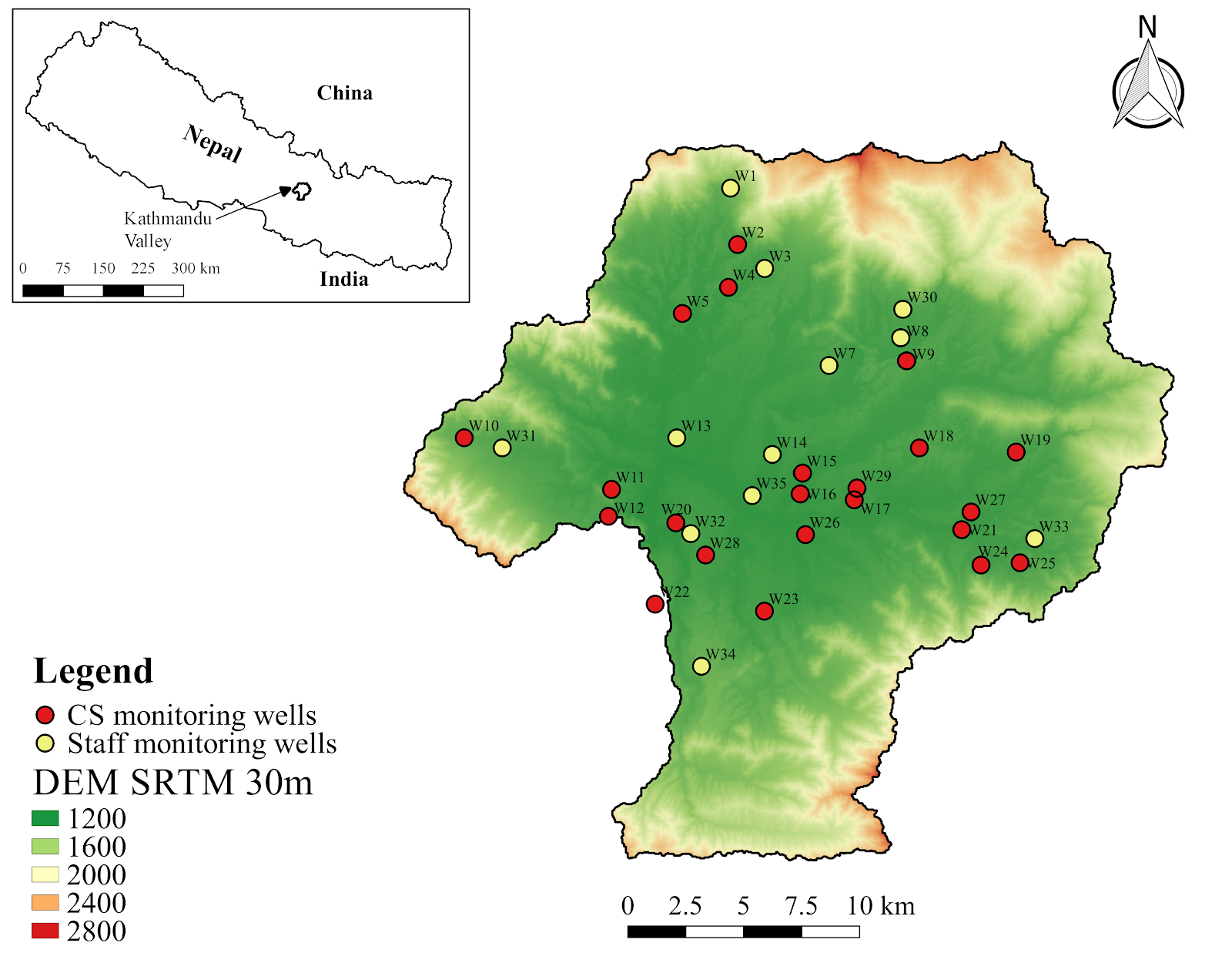
Therefore, Smartphones For Water Nepal (S4W-Nepal) started monitoring groundwater levels in the Valley in 2017 through a citizen science approach. Citizen science engages the general public in the scientific research design, data collection, analysis, and other scientific works in collaboration with professional scientists (Cappa et al., 2018). Also, it increases the scientific knowledge of the local people or Citizen Scientists (CS), in this example with regards to groundwater level fluctuations. We at S4W-Nepal intend to continue to monitor groundwater levels and expand our data’s spatial coverage by following this feasible and sustainable approach. In order to monitor groundwater levels, we have selected certain existing wells in the Valley, considering their spatial location and distribution. Figure 2 shows the location of regular monitoring wells of S4W-Nepal, including both CS and staff sites. Unlike other water resources monitoring projects, S4W-Nepal promotes sustainable monitoring of groundwater resources by converting the existing wells into monitoring wells and involving CS in collecting groundwater level data. In the middle of every month, our citizen scientists record the groundwater level with a measuring tape and an android application called Open Data Kit (ODK) Collect. The CS can easily record the date and time of data collection, location of monitoring well, and the depth to water in meters (along with photos taken on site) through a customized form developed by S4W-Nepal in ODK Collect and forward it to the server of S4W-Nepal. Once data are received, we perform quality control and do immediate follow-up calls to minimize errors.
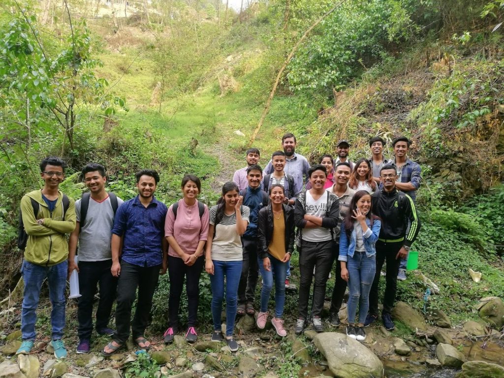
S4W-Nepal’s Citizen Scientists for monitoring groundwater level
We recruit most of our CS through a variety of outreach programs, social media, and personal contacts. There is no age, gender, and educational restriction to become a CS; anyone interested in the scientific process of data collection can become a CS. To date, S4W-Nepal has recruited and trained 86 CS to monitor groundwater levels. Understanding groundwater level variation and supporting the sustainable management of groundwater resources motivates our CS to collect the data regularly. The age of CS involved in S4W-Nepal for monitoring gw level data ranges between 15 – 33 years, and the majority of them are students from different educational backgrounds. Out of our 86 CS, 40 (46.5%) are female and 46 (53.5%) are male. We currently have 23 regular CS collecting monthly groundwater level data from different locations of the Valley. We regularly communicate with our CS through follow up calls/SMS with monthly reminders or follow-up on data collection, to see if they have any questions, and to encourage them to continue data collection and their involvement. One of the challenges of citizen science projects is maintaining and seeking to improve the engagement of CS over time.
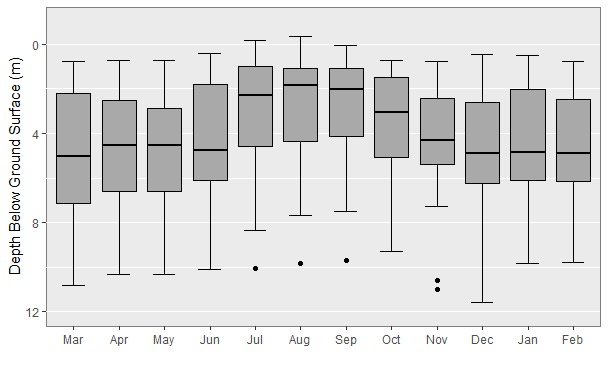
Temporal variation of groundwater levels in the Valley
Based on the groundwater level data collected by our CS from March of 2019 to February of 2020, a preliminary analysis has been done to understand the temporal variation of groundwater levels of the Valley (Figure 3). Data from 35 regular monitoring wells have been taken into consideration in this analysis.
The boxplot below reveals the monthly fluctuations of groundwater in the time period of 1 year. The groundwater level is maximum during the monsoon season (June- September), and the groundwater level is lowest in December of 2019 (i.e., post-monsoon period). Also, the groundwater levels dropped sharply from October of 2019, the beginning of the post-monsoon period. This indicates the direct influence of rainfall on the groundwater level.
Despite the critical need for groundwater monitoring, there is still a significant data gap that needs to be closed to better understand groundwater fluctuations across the Valley and under varying conditions. Therefore, the regular monitoring of the groundwater level by using a citizen science approach should be continued and expanded. Besides, it will make the general public more aware of groundwater conditions, more actively involved in monitoring and managing this critical resource, and will promote proper groundwater resources management.
References
Ahmed, F. (2002) Water Supply options. Available from URL: http://wilsonweb.physics.harvard.edu/arsenic/conferences/Feroze_Ahmed/Sec_3.htm [Accessed on 18th November, 2020]
Ahuja, S., Larsen, M. C., Eimers, J. L., Patterson, C. L., Sengupta, S. and Schnoor, J. L. (2014) Comprehensive water quality and purification. Waltham, MA: Elsevier.
Aryal, R. S. (2011). Ground water reality.New Spotlight. 4(19). March 25, 2011.
Cappa, F., Laut, J., Porfiri, M. and Giustiniano, L. (2018) Bring them aboard: Rewarding participation in technology-mediated citizen science projects. Computers in Human Behavior [online]. 89, pp.246-257. Available from DOI: 10.1016/j.chb.2018.08.017
Earman, S. and Dettinger, M. (2011) Potential impacts of climate change on groundwater resources – a global review. Journal of Water and Climate Change [online]. 2(4), pp. 213–229. Available from DOI: 10.2166/wcc.2011.034
Ghimire, S. and Johnston, J,M. (2015) Traditional Knowledge of Rainwater Harvesting Compared to Five Modern Case Studies. Conference: Environmental and Water Resources Congress 2015 [online]. Available from DOI: 10.1061/9780784479162.017
Shrestha, R.R. (2009) Rainwater harvesting and groundwater recharge for water storage in the Kathmandu Valley. ICIMOD Newsletter [online]. 56, pp.27-30. Available from URL: https://www.indiawaterportal.org/sites/indiawaterportal.org/files/Water%20Storage_%20Climate%20Change%20Adaptation%20Strategy_%20ICIMOD_2009.pdf#page=29
Shrestha, S. (2017) The contested common pool resource: Ground water use in urban Kathmandu, Nepal. The Geographical Journal of Nepal. 10, pp. 153-166.