Smartphones For Water Nepal (S4W-Nepal) organized the Post-Monsoon Citizen Scientists (CS) Celebration on the 27th of November 2021 at Alfa House Banquet, Baneshwor to commemorate the success of the ‘Monsoon Expedition 2021’. S4W-Nepal had aimed this program to be a gesture of gratitude towards its CS for their time and dedication during the entire expedition. Dr. Dinesh Pathak, the President of S4W-Nepal and a Professor at the Central Department of Geology of Tribhuvan University, had been invited as the chief guest of the event. Shortly after a brief introductory session of the participants, the program was commenced by Ms. Priya Silwal, the Research Associate of S4W-Nepal, with an introduction on S4W-Nepal and its activities. It was then followed by the presentation on “Citizen Science-based Monsoon Expedition” by Mr. Sudeep Duwal, the Research Associate of S4W-Nepal. He discussed the importance of the citizen science approach in generating the data with good spatial coverage for a better understanding of the rainfall pattern of the Kathmandu Valley (Valley). He also explained about the reliability of a cost-effective S4W rain gauge and demonstrated the comparison of CS-generated rainfall data with the rainfall data generated by the Department of Hydrology and Meteorology (DHM).
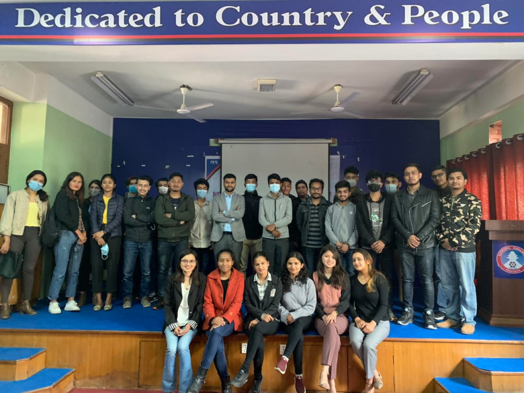
Figure 1: Group photo of the participants of the event
The major highlight of the program was the certificate distribution session. The participants of the Monsoon Expedition 2021 were awarded with certificates of appreciation by the chief guest for their continued enthusiasm throughout the expedition. Ms. Susa Manandhar was awarded with the title of ‘Rainfall CS of the year’ for 2021, and was given a token of appreciation for her significant contribution in taking daily rainfall measurements. The ‘CS of the month’ for each month throughout the expedition were also acknowledged during the event. Moreover, the CS who have been actively participating in the annual monsoon expedition of S4W-Nepal since 2018 were also applauded with a token of appreciation. Apart from that, certificates were provided to the past executive team (2020/2021) of the Young Researchers’ Circle (YRC) for their remarkable work throughout their tenure.
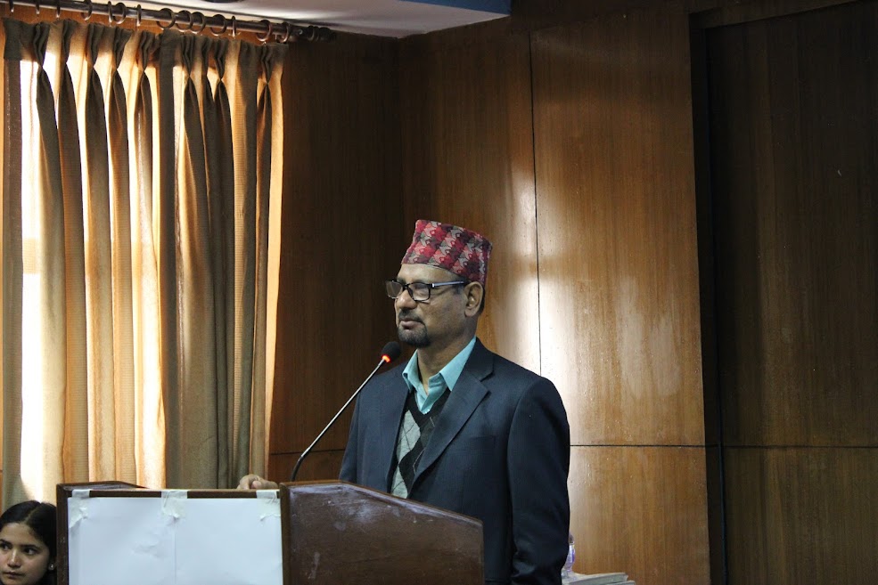
Figure 2: Chief guest Dr. Dinesh Pathak delivering his remarks
After the certificate distribution session, the chief guest, Dr. Pathak gave his valuable remarks regarding the applicability of S4W-Nepal’s Citizen Science approach in generating hydro-meteorological data in resource-constrained areas like Nepal. He stated that precipitation is a pivotal component of the hydrological cycle and groundwater is a precious freshwater resource of our country, extensively available for consumption. Therefore, there is a crucial need for monitoring the precipitation and understanding the groundwater recharge potential to effectively manage the available water resources. He further explained the difficulties in understanding the microclimatic events of Nepal due to insufficient DHM hydrometeorological stations, and applauded S4W-Nepal for its remarkable steps in the field of science for collecting the much-needed data. Further, some interested CS also shared the experiences regarding their participation in the monsoon expedition. Most of them stated that they feel extremely happy to be a part of this campaign playing a significant role in rainfall data generation in a data scarce country like Nepal. Some of them mentioned how their involvement in the expedition has increased their concern and curiosity regarding hydrological research in the country and boosted their enthusiasm to contribute to it.
The formal program was concluded by Mr. Rajaram Prajapati, the Chief Executive Officer (CEO) of S4W-Nepal, with his words of thanks. He thanked all the CS and young researchers for their active involvement in preparing their own rain gauge for the monsoon expedition of 2020 and 2021, amidst the restrictions of the COVID-19. He added that it is impossible to use expensive trackers and entirely depend upon the government for data generation in disaster-prone developing regions like Nepal, so each citizen must play their part in research activity. He further added that the DHM data is insufficient for drawing reliable conclusions, so the CS-generated data is extremely valuable for the long run and it should be kept up to date. He mentioned how he believes in making science simple and visible and concluded his words with his plan to work in flood monitoring.
Figure 3: The CEO of S4W-Nepal, Mr. Rajaram Prajapati giving the concluding remarks
The formal session was concluded by taking a group photo and it was followed by an interactive session where the participants actively interacted with their counterparts. The feedback and suggestions of the CS were also collected by requesting them to fill the feedback sheets to make necessary improvements to the expedition in the upcoming years. There were 34 participants in total including the CS, YRC executive members, and S4W-Nepal staff in the event, which was moderated by Ms. Anusha Chalise, the Research Assistant of S4W-Nepal. The entire S4W-Nepal team looks forward to conducting similar events to enhance their relationships with their hardworking CS, and make it simpler and easier for them in further projects.
Young Researchers’ Meet, the first physical event of the Young Researchers’ Circle (YRC), was hosted by YRC and Smartphones For Water Nepal (S4W-Nepal) on 20th March 2021 at Khwopa College, Bhaktapur. The main objective of this interactive event was to provide some valuable insights to the participants regarding the prevailing water resources management issues in Nepal and some possible solutions. The best part of this event was the presentations delivered by the guests. After the brief introductory presentation about YRC by the coordinator of YRC, Ms. Priya Silwal, Mr. Anoj Khanal, a geologist at the Kathmandu Valley Water Supply Management Board (KVWSMB) presented on the topic “Evidence-based groundwater management – A Case study of Kathmandu Valley”. He enlightened the audience about the present status of groundwater resources in the country and the role of several government organizations like KVWSMB in groundwater resource management. He described how ironic it is that the management approaches related to groundwater resources in Nepal are dependent upon the data generated about 30 years ago. He talked about the crucial need to conduct a detailed study about the present condition of groundwater aquifers of the Valley to make the groundwater management approaches more effective.
Figure 1: The guests (Left Mr. Tika Gurung right Mr. Anoj Khanal) delivering the presentations on their respective topics
Then, our second guest lecturer, Mr. Tika Gurung, the research associate of the International Centre for Integrated Mountain Development (ICIMOD), demonstrated the findings on “Glacier mass and energy balance studies in two glaciers of Nepal.” He focused on the detailed study conducted by his team on monitoring the two glaciers: Yala and Rikha Samba in the Langtang Valley. He also enlightened the audience about the methods used to monitor the glaciers and also explained his findings about the effects of climate change observed in the glaciers of Nepal. Also, he shared his personal experiences associated with the research.
The program was concluded by Mr. Rajaram Prajapati, the CEO of S4W-Nepal, with his words of thanks. Briefly highlighting the motive of establishing YRC, he encouraged the audience to utilize their opportunity of getting involved in a circle of such innovative minds and show their active participation in its activities. The event was moderated by one of the executive members of the YRC, Ms. Sumnima Ghimire. Shrena Shrestha, an enthusiastic Executive Member of YRC, was rewarded with the ‘Rainfall CS of the Year 2020’ award of S4W-Nepal for her significant contribution in taking daily rainfall measurements in the S4W-Nepal’s ‘Monsoon Expedition 2020’. The event was conducted on the occasion of the Nepal National Weather and Water Week (NNWWW). It was basically a public platform where young people from different educational backgrounds interested in the management of water resources participated. The audience, mainly composed of students of different backgrounds such as environmental science, engineering, meteorology, and geology, had an active interaction with the presenters on their respective topics. We look forward to such events in the future that will boost our understanding regarding water resources and research skills.
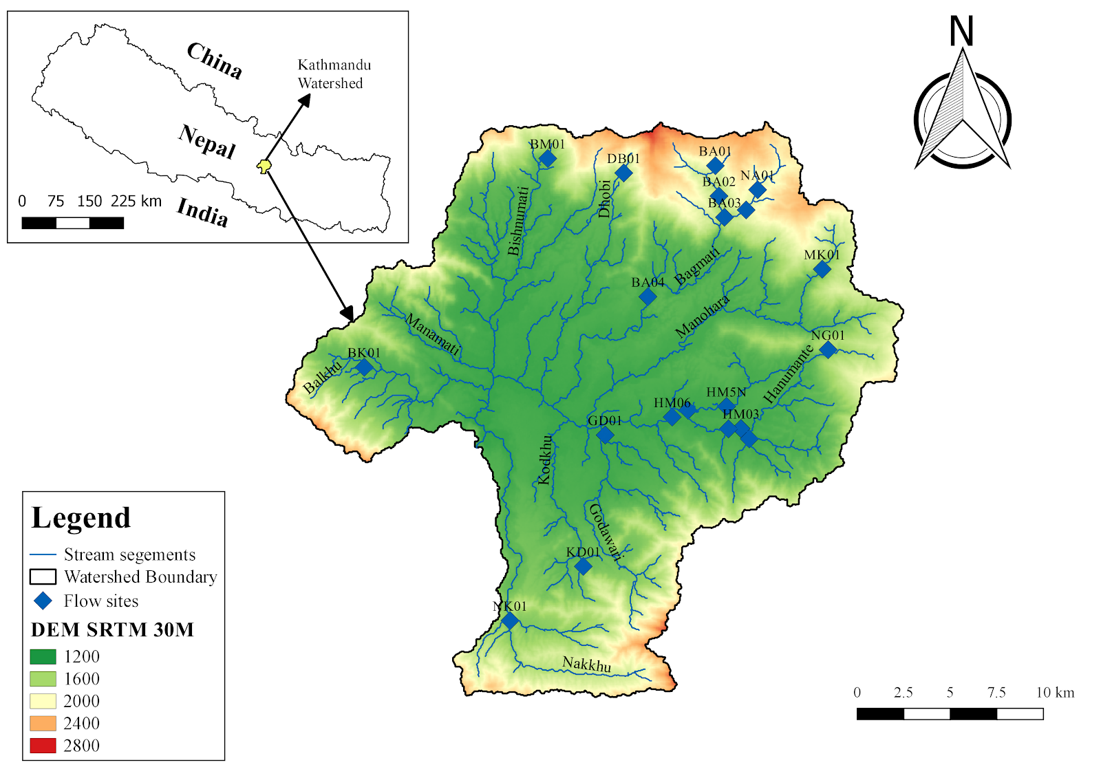
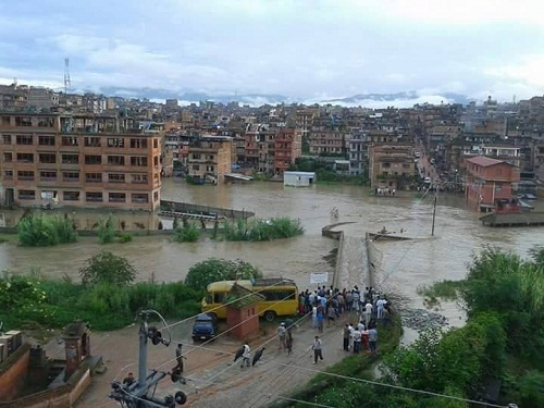
Flooding is regarded as one of the critical concerns in urban areas of Nepal, especially Kathmandu Valley (KV). The frequency of urban flooding in the KV has increased dramatically over the recent years owing to abrupt population growth, and unplanned urbanization (World Bank, 2017). Apart from that, river pollution is widely prevalent in the KV, which has ultimately affected the urban ecology of the streams. Among the different tributaries of the Bagmati river in the KV, the Hanumante river is highly prone to urban flooding, and water pollution. Although the river has several cultural/irrigational significance (Shrestha 2007; Sada, 2012) and its upstream is a critical source of water to the inhabitants, the river has become tremendously stressed in recent years. The river has experienced the two largest incidents of flooding in the last decade (2015 and 2018), which had several detrimental impacts.
Figure 1: Flooding Hanumante Watershed in 2015 (left) and 2018 (right).
Furthermore, the flood risk seems to be emerging with each passing year. This can be attributed to the encroachment of the floodplains for settlement purposes and the government lags for developing/implementing proper land use policy (Prajapati, 2018). The direct discharge of untreated household sewage and industrial effluents, pesticides from agricultural runoff has led the Hanumante river to be severely polluted. These two critical issues of the Hanumante river have posed significant socio-economic challenges/impacts in the livelihood of the people living nearby; majorly by the inundation of the agricultural and settlement area, health hazards associated with pollution of the river, and so on. As such, proper hydrometeorological data are crucial to understand the flood dynamics, propose effective mitigation measures to the associated stakeholders/policymakers, and manage the river in a sustainable manner. There are already four rainfall stations installed by the Department of Hydrology and Meteorology (DHM) in different places of the Hanumante Watershed (Changunarayan, Nangkhel, Nagarkot and Suryabinayak). However, much effort has not been made in the last decade to collect the water level/streamflow/quality data of the Hanumante river.
Figure 1: A map of the study area (Hanumante watershed) showing monitoring sites (red dots).
Realizing the need for hydrological monitoring in the Hanumante Watershed, Smartphones For Water (S4W-Nepal) has been gathering hydro-meteorological data of the Hanumante river since 2019 with the help of Citizen Scientists (CS) and young researchers. S4W-Nepal has been monitoring the stream water level using staff gauges, and bimonthly stream discharge using Acoustic Doppler Velocimeter at the 12 different sites of the Hanumante river (Figure 1). Along with that, S4W-Nepal has been collecting a few physicochemical water quality parameters such as temperature, pH, Electrical Conductivity (EC), Total Dissolved Solids (TDS), and dissolved oxygen using respective portable water quality meters. Besides, S4W-Nepal in collaboration with the High Powered Committee for Integrated Development of Bagmati Civilization (HPCIDBC) have been monitoring the important water quality parameters, including pH, Turbidity, Total Suspended Solids (TSS), Biological Oxygen Demand (BOD), Chemical Oxygen Demand (COD), Fecal coliform, and total phosphate) from nine different sites of Hanumante river.
Figure 2: Map showing seasonal discharge (m3/s) in the 12 different sites of the Hanumante river in i) Pre-monsoon, ii) Monsoon, iii) Post-monsoon and, iv) Winter (2019 to 2021).
Hanumante Watershed receives 80% of total annual rainfall within the monsoon season i.e., June-September. The seasonal variation of streamflow in the Hanumante river from 2019 to 2021 is clearly presented in Figure 2. It is evident that the streamflow in the Hanumante river is majorly dependent upon monsoonal rainfall. The discharge of all three major tributaries is less than 0.2 m3/s in all seasons, which increases to 1.2 m3/s or more after the confluence in monsoon and post-monsoon seasons. However, during pre-monsoon and winter, the discharge of the stream remains moreover constant i.e., less than 0.4 m3/s from upstream to downstream, which is likely due to the insignificant rainfall, extraction of water for irrigation and construction purposes, and groundwater percolation (Wang, 2013). Besides, a recent study has suggested that the estimated return period of the water level of about 3.5m in the Hanumante river is ten years (Kindermaan, 2020).
As per the recent data by HPCIDBC at nine different sites, the overall water quality of Hanumante river in post-monsoon of 2021 was found to be adversely degraded. It was found that the water quality parameters for the majority of sites exceeded the National Water Quality Guidelines for Irrigation Water/Aquaculture. This suggests that the water quality of the Hanumante is not suitable for the irrigational purposes and aquaculture. Further, the sites located in the dense settlement areas of the Bhaktapur district (downstream of Hanumante river) were found to be highly polluted, which might be due to the multiple anthropogenic influences.
In the coming days, S4W-Nepal intends to continue monitoring the streamflow, water level, and quality even more intensely and generate some meaningful inferences/information, which will support the management of Hanumante river. The regular monitoring of Hanumante river is crucial to determine flood frequency, return level and maximum flood level, which can assist in designing flood mitigation plans, and reducing the dreadful impacts of flooding Moreover, local government/organizations, academic institutions, and responsible authorities should work together with specific goals and plans for better management of the river. The management of the river in a sustainable manner along with local participation should be the utmost priority of all the concerned stakeholders.
References
Kindermann, P.E., Brouwer, W.S., van Hamel, A., van Haren, M., Verboeket, R.P., Nane, G.F., Lakhe, H., Prajapati, R. and Davids, J.C.\ (2020) Return level analysis of the hanumante river using structured expert judgment: A reconstruction of historical water levels. Water, 12(11), pp.3229. Available from DOI: https://doi.org/10.3390/w12113229
Prajapati, R., Raj Thapa, B. and Talchabhadel, R (2018) What flooded Bhaktapur? My Republica, 17 July 2018.
Sada, R. (2012) Hanumante River: Emerging uses, competition and implications. Journal of Science and Engineering, 1, pp.17-24.
Wang, S.Y., Yoon, J.H., Gillies, R.R. and Cho, C. (2013) What caused the winter drought in western Nepal during recent years?. Journal of Climate, 26(21), pp.8241-8256.
World Bank (2017) Land Use Planning for Urban Flood Risk Management. Urban Floods Community of Practice Knowledge Notes. The World Bank, 2017.
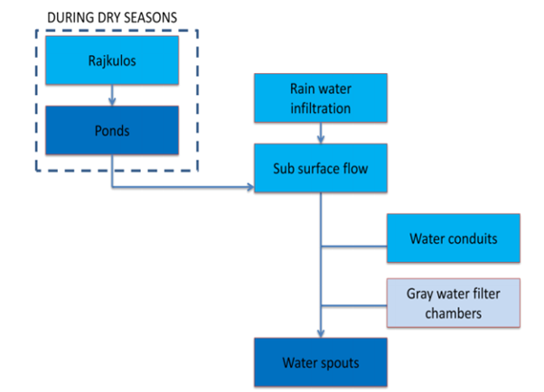
The hiti system is the cornerstone of the ancient water management system in the Kathmandu Valley, Nepal. The hiti system was introduced in the Valley even before the Lichhavi period (400-750 A.D.), and its network was expanded during the Malla period (Shrestha and Maharjan, 2016). A hiti (stone spout in English) is a traditional water resource usually present at a man-made depression in which water is channeled from a source to function as a tap. The traditional hiti system is an integrated water supply system that incorporates major sources of water i.e., rainwater, groundwater, and surface water resources. The hiti system consists of five major components:
Figure 1: Flowchart showing the working of the traditional water supply system.
Intake
The conveyance canals and the rajkulos
The stone spouts or the hiti
The pukhus and wells
The drainage system /
This traditional water system has served as one of the vital water sources required to meet water demands during dry days since ancient times. It is still actively used for drinking purposes by the locals residing in some core areas of the Valley. Recent studies have shown that the existing stone spouts of the Valley have been contributing to fulfill the water demands of about 10% of its population (Tripathi et al., 2019). Besides its significance in terms of water supply, the hiti system possesses considerable historical and cultural importance. However, the system has not been valued and often neglected by both the community and the state after the introduction of the modern piped supply system in 1950 A.D. (UN-HABITAT, 2008). At present, the traditional water supply systems (stone spouts, ponds, and wells) are in defunct conditions owing to the weak management capabilities of the government, the absence of proper policies, and lack of ownership. According to the Kathmandu Valley Water Supply Management Board (KVWSMB) report, there are 573 stone spouts and 233 ponds in the Valley, out of which 94 stone spouts and 40 ponds are completely lost (KVWSMB, 2019). Therefore, the existing traditional hiti system and its components should be monitored, conserved, and actions should be taken for the revival of the system.
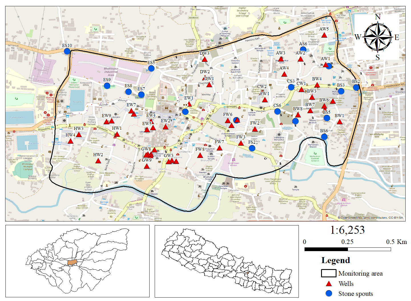
Figure 2: Study area showing the location of monitoring wells and stone spouts.
Smartphones For Water Nepal (S4W-Nepal) has been monitoring the traditional hiti system of the Bhaktapur Municipality (BM) through a feasible citizen science approach. In order to monitor the hiti system of the BM, S4W-Nepal has recruited and trained 13 Citizen Scientists (CS) who are currently pursuing their bachelors. The CS have been recording monthly data of the discharge/quality of 16 stone spouts and the groundwater level/quality of 49 wells since 2019. Based on the collected data, S4W-Nepal aims to study the water distribution mechanism, the interactions of the stone spout with the neighboring wells and ponds, and also initiate the study on the possibilities of the revival of the system. Figure 2 shows the locations of the monitoring wells and stone spouts of S4W-Nepal. In the mid of every month, our CS measure the groundwater level using a measuring tape, and stone spout discharge by the help of a measuring cylinder. The stone spout discharge is calculated by determining the volume of water filled in the measuring cylinder within a certain period of time. Certain water quality parameters including temperature and Electrical Conductivity (EC) are also monitored using the HoneForest EC meter. An android application called Open Data Kit (ODK) Collect was used as a data collection platform.
Seasonal variation of groundwater levels and stone spouts discharge
A preliminary analysis has been carried out considering the monthly groundwater level and stone spouts discharge data collected by our CS from March 2019 to February 2021. The monthly data was transformed into seasonal data to understand the seasonal variation.
Figure 3: Boxplot showing the seasonal variation of groundwater level from March 2019 to February 2021
Figure 4: Boxplot showing the seasonal variation of stone spouts discharge from March 2019 to February 2021.
The boxplots (Figure 3 and 4) show the seasonal fluctuation of the groundwater level and stone spouts discharge in the period of two years (March 2019 to February 2021). The groundwater level was maximum during the pre-monsoon in both 2019 and 2020 and lowest during the post-monsoon in 2019 and monsoon in 2020. Similarly, the discharge was observed to be highest during the monsoon season in 2019 and post-monsoon in 2020. Over the study period, the discharge was lowest during the pre-monsoon season, followed by winter. However, it was found that the overall discharge of the stone spout in all four seasons was higher in 2020/2021 compared to 2019/2020. The higher precipitation in 2020 compared to 2019 is the possible cause for such variation in the groundwater level and stone spout discharge in the two years. The overall seasonal trend in the fluctuation of the groundwater level and stone spouts in both years was almost similar, indicating high dependence of the groundwater level and water discharge on rainfall. As the trend is similar in both boxplots, it can be assumed that there exists a certain degree of interactions between stone spouts and wells of the BM.
Interactions between stone spouts and wells in terms of EC
Figure 5: Spatial variation of EC in the stone spouts and wells during monsoon 2019/2020Figure 6: Spatial variation of ECin the stone spouts and wells during post-monsoon 2020/2021
The parametric values of EC recorded by our CS in the two years were analyzed to understand the interactions of the wells and stone spouts. The above map (Figure 5) shows the spatial variations of EC in the stone spouts and wells of the BM. It can be observed that the well AW1 and stone spout BS3 lie nearer to each other and their EC values were also similar. Similarly, the stone spout CS3 and the wells CW1 and BW4 had close EC values. Furthermore, the stone spout CS5 and the well BW8 showed almost the same EC values. So, the aforementioned stone spouts and wells were found to interact in terms of EC and may have the same source. However, any strong conclusion can’t be drawn on the basis of this finding, since only one parameter was taken into account.
Furthermore, similar studies including multiple water quality parameters along with proper site selections should be carried out to fully comprehend the interactions between stone spouts and wells. The traditional hiti system is a very unique water heritage with great architectural and cultural significance and can serve as an excellent source of drinking water, particularly in the water-scarce region like the Valley. The degradation of traditional water resources not only causes a water supply deficit but also poses a significant influence on the historical and traditional aspects of the Valley. Therefore, the conservation and preservation of the existing traditional hiti system should be promoted and studies related to the feasibility for the revival of their components should also be initiated by the concerned authorities and organizations.
Reference
Shrestha, R.P. and Maharjan, K.L. (2016) Traditional water resource use and adaptation efforts in Nepal. Journal of International Development and Cooperation, 22(1&2), pp.47-58. Available from URL: https://core.ac.uk/download/pdf/222955771.pdf [Accessed 12th May 2021]
Tripathi, M., Hughey, K. F. D. and Rennie, H. G. (2019) The State of Traditional Stone Spouts in Relation to Their Use and Management in Kathmandu Valley, Nepal. Conservation and Management of Archaeological Sites.20 (5-6), pp 319-339. Available from URL: https://www.tandfonline.com/doi/abs/10.1080/13505033.2018.1559421 [Accessed 12th May 2021]
UN-Habitat (2008) Water Movement in Patan: With Reference to Traditional Stone Spouts in Nepal. United Nations Information Centre, Kathmandu Nepal: United Nations Human Settlements Programme.Kathmandu Valley Water Supply Management Board, Government of Nepal (2019). Stone spouts and ponds of Kathmandu Valley. Kathmandu, Nepal: Government of Nepal, Ministry of Water Supply and Kathmandu Valley Water Supply Management Board.
Headwater streams are small and numerous capillaries of stream networks and comprise a significant portion of aquatic ecosystems. Headwaters are defined as a watercourse within the first 2.5 km of its furthest source, occurring over a range of climate, geology, hydrology, and biogeographical settings (Callananet al., 2008). In contrast to downstream reaches, headwater streams are characterized by their close interactions with the hill slopes processes, more spatiotemporal variation, and their extra need for different means of protection from land use (Gomi et al., 2002). Headwaters streams are necessary for understanding and protecting downstream ecosystems as they are intimately linked. Given their importance and growing pressures on aquatic resources, understanding the drivers of headwater flow must be improved to facilitate wise land and water management decisions.
In the Kathmandu Valley (Valley), headwaters are mostly present in the outskirts of the developed areas and are near natural land uses. Headwaters are clean and pure and provide water to meet the domestic and irrigation demands of the population living in the Valley. The domestic water demand in the Valley was 415.5 million liters per day (MLD) in 2016, which is expected to increase to 540.3 MLD by 2021 (Udmale et al., 2016). To supply fresh water to the entire Valley population, Kathmandu Upatyaka Khanepani Limited (KUKL) has tapped headwater streams and springs into reservoirs. Regardless of their significance, headwater streams are underestimated and poorly managed compared to the downstream streams. These streams are channelized, diverted, polluted, and at worst destroyed. The headwaters should be conserved in order to sustain the downstream population.
Therefore, Smartphones for Water Nepal (S4W-Nepal) has started monitoring these headwater streams since 2018 by involving young researchers and citizen scientists. As a part of headwater stream monitoring, S4W-Nepal has been collecting hydrological data that includes stream water level, stream discharge along with their water quality of the 14 different headwaters of the Kathmandu Valley.
Figure 1: Study area watershed showing streamflow measurement sites
Figure 1 shows the monitoring sites of the S4W-Nepal. Every month, young researchers from S4W-Nepal perform United States Geological Survey mid-section method discharge measurements with a SonTek FlowTracker Acoustic Doppler Velocimeter and measure the water level from a staff gauge installed in the streams. Furthermore, they also collect few water quality parameters such as temperature, EC, pH, and TDS. All the data are recorded using an android application called Open Data Kit (ODK) Collect. S4W-Nepal intends to increase its stream monitoring network in the future by involving a greater number of citizen scientists.
Dr. Rijan Bhakta Kayastha Himalayan Cryosphere, Climate and Disaster Research Center (HiCCDRC) Department of Environmental Science and Engineering, School of Science, Kathmandu University, Dhulikhel, Kavre, Bagmati Province, NEPAL
Nepal is rich in water resources because of its monsoon, snow-covered area, and a number of glaciers in the Himalayas. However, the hydrological responses of the snow-covered and glaciated zones are distinct from the other zones of Nepal. The water resource of Nepal is heavily dependent on monsoon dynamics and the state of the snow and glacier ice in the Himalayas. Climate change affects both monsoon dynamics and snow and glacier ice in the Himalayas. In addition to this, climate change is also responsible for the increasing number of glacial hazards recently in Nepal.
Glacier is a moving body of snow and ice that has been formed as a recrystallization of snow and a glacial lake is a lake that is formed by glacial activity. Glacial hazard includes any hazard in a glaciated region such as snow and ice avalanche, flash flood due to supraglacial lake draining, and rapid melting of snow and ice of a glacier, Glacial Lake Outburst flood (GLOF), ground subsidence due to rapid thawing of permafrost and heavy snowfall in a glaciated region, etc.
Many studies have shown retreat of glaciers, expanding existing glacial lakes and forming new lakes and altitude of a lower limit of permafrost are shifting upward in the Nepal Himalayas. There are 19 glacierized sub-river basins from east to west in which there are 3,808 glaciers and 2,070 glacial lakes in Nepal (Bajracharya et al., 2020). Total 47 glacial lakes in Nepal, Tibet, China, and India are classified as Potentially Dangerous Glacial Lakes to Nepal because if these glacial lakes are drained, the flood water will enter into Nepal and damage considerably. Out of 47 potentially dangerous glacial lakes in the Himalayas, 25 are in Tibet, China, 21 in Nepal, and 1 in India. This renders much of the infrastructure along the rivers originating from these lakes at immediate risk.
A 2011 study by ICIMOD reported 24 GLOF events in the past, 14 of which had occurred in Nepal, while 10 were caused by overspills due to flood surges across China (TAR)‒Nepal border (ICIMOD, 2011). On 4 August 1985, a Dig Tsho GLOF event swept away three persons, one hydropower plant, 14 bridges, and 35 houses along the Dudh Koshi River. Table 1 shows major GLOF events since the 1980s that have caused damages in Nepal. Since GLOF events are increasing recently, in order to reduce the risk from such events again the Department of Hydrology and Meteorology, Government of Nepal has reduced the water level of Tsho Rolpa Glacial Lake in Dolakha district by 3 m in 2000 and that of Imja Glacial Lake in Solukhumbu district in 2016 by 3.4 m successfully.
Table 1. GLOF events since the 1980s that have caused damages in Nepal.
S. No.
Date
River basin
Location
1
23 June 1980
Tamor
Nagma Pokhari
2
11 July 1981
Bhote Koshi
Cirenmacho Lake, Zhangzangbo Valley
3
4 August 1985
Dudh Koshi
Dig Tsho
4
12 July 1991
Tama Koshi
Chubung
5
3 September 1998
Dudh Koshi
Sabai Tsho (Tam Pokhari)
6
5 July 2016
Bhote Koshi
TAR, China
7
20 April 2017
Barun Valley
Near Lower Barun
In the recent past, also a few flash flood events in the glacierized river basins of Nepal are occurring mainly due to irregular monsoon activity and sudden warming epochs in some regions. Seti flash flood on 5 May 2012 due to snow, ice, and rock avalanche, a Glacial Lake Outburst Flood (GLOF) on 5 July 2016 in Bhotekoshi River in Tibet, China, and a flash flood on 20 April 2017 in Barun River are a few examples. Such events have increased the risk of glacial hazards, especially in the high mountain areas. Therefore, it is high time to monitor weather, snow, glaciers, glacial lakes of the high Himalayas by establishing suitable stations and need to install early warning systems in downstream of such glacierized river basins in Nepal.
Snow and weather monitoring stations at high altitudes will be also useful to analyze possible snow hazards and then flash floods in the downstream as such occurred in Seti River in Nepal on 5 May 2012, heavy rainfall resulting rapid melting of snow and ice from Chorabari Glacier in Kedarnath, India on 16 June 2013, heavy snowfall by Cyclone Hudhud on 13 October 2013 in the Annapurna region, Nepal, and the recent Chamoli flash flood in Uttarakhand in India on 7 February 2021 due to snow, ice, and rock avalanche. Since weather, snow, glacier, and glacial lake monitoring stations are very rare in the Nepal Himalayas, it is very high time to establish such stations across Nepal to reduce and prevent damages caused by glacial hazards in Nepal.
References:
Bajracharya, S. R., Maharjan, S. B., Shrestha, F., Sherpa, T.C., Wagle, N., Shrestha, A. B.
(2020). Inventory of glacial lakes and identification of potentially dangerous glacial lakes in the
Koshi, Gandaki, and Karnali River Basins of Nepal, the Tibet Autonomous Region of China, and
India. Research Report. ICIMOD and UNDP.
ICIMOD (2011). Glacial lakes and glacial lake outburst floods in Nepal. Kathmandu: ICIMOD. Note: ‘Young Researcher’ Issue 05 – May 2021
The set of framework and guiding principles that provide an environment for collective management of groundwater for sustainability, equity, and efficiency can be understood as groundwater governance. The groundwater resources vary widely with natural variation and geological heterogeneity. Therefore, governance must be adapted to the local context. Groundwater, being an integral part of the hydrological cycle, needs to be managed in conjunction with linked water and land resources. Over time, groundwater extraction in Nepal for different purposes has been growing gradually (driven by demography, technology, and changing lifestyles), resulting in threats to its sustainability. This indicates that sound governance is a pressing priority. However, the development and implementation of several components of the governance are creating a larger governance gap.
Er. Bhesh Raj Thapa International Water Management Institute
In Nepal, intensive groundwater extraction, pollution by inadequate sanitation and wastewater treatment, pollution by industry and agriculture, inequitable allocation, inefficient use, and land subsidence are the key issues and challenges for groundwater management, mainly in bigger cities and the Terai area. In addition to this, the role of groundwater actors and their mode of interaction, regulatory and institutional framework, policies development, and their implementation is not well understood and not in function. Such frameworks and policies need to be revisited for good governance in the groundwater sector. Although several water-related laws and regulations focusing on groundwater have been made, groundwater has practically remained an unregulated resource in Nepal.
The cities like Kathmandu have been facing negative consequences like drying of traditional water sources, decreasing well yields, and declining groundwater levels due to excess extraction rather than recharge. Groundwater act, regulation, and policy exist, but the mechanism and dynamics of changes for sustainable management of groundwater have not been properly addressed till date. Overlapping responsibilities and sectoral conflicts in water institutions in most of the major cities are causing weak governance in the water sector. In addition to this, poor understanding of hydrological dynamics of conjunctive water use and local hydro-geological complexities are also major constraints for sustainable groundwater management through policy formulation and implementation.
Improving groundwater governance is not easy, hence the responsible local institutions have to make their judgement based on the regulation and policies to suggest feasible and effective measures in the current situations. All the relevant parties need to commit and cooperate towards a common goal for effective groundwater governance. Good governance will mainly be guided with four sets of principal and consideration: political and institutional (accountability, representation, consistency, institutional capacity etc.); socio-cultural (religious and spiritual traditions, social learning, social inclusion, ethics etc.); economic (price signal, groundwater storage condition, water quality impacts, willingness to pay etc.); ecological (storage, attenuation rate and renewability, land uses etc.). To improve the groundwater governance, it needs to be treated in a holistic approach and proper management instrument and measures need to be selected based on the local condition. Their effectiveness not only depends on the local physical, institutional, economic and social condition but also on the way these measures are designed and implemented. In addition to this, information and knowledge regarding local conditions need to be shared and awareness related to the baseline of the groundwater resources and their safe limit need to be raised for good groundwater governance. Reaching an effective level of awareness is the first step towards structural communication between decision-makers, planners, groundwater specialists and stakeholders. For adequate groundwater management, a powerful and effectively operating groundwater organization is a must. In addition to this, the laws related to groundwater allow for a connection between the policies of groundwater and those of the related field such as surface water management, land use planning, and environmental protections.
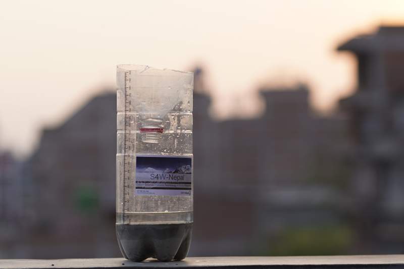
Citizen science is an approach to science that engages and includes the general public in scientific research, which has the benefits of connecting the general public with professional scientists and increasing their scientific understanding (Keyles, 2020). Smartphones For Water Nepal (S4W-Nepal) appreciates these benefits and employs this approach. For more than four years S4W-Nepal has conducted the Monsoon Expedition in the Kathmandu Valley (Valley) by mobilizing citizen scientists, mobile technology, and young researchers to measure precipitation during the monsoon (roughly May to September). The citizen scientists use a cost-effective rain gauge and an android phone to perform daily rainfall measurements. The S4W-Nepal rain gauge is made of recycled clear plastic bottles (Coke or Fanta) of 2.15 liters having a uniform diameter of 100 mm, a concrete base, and a ruler with millimeter gradations (Figure 1).
Figure 1: S4W rain gauge
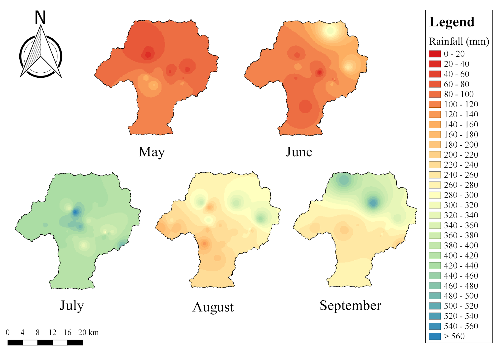
Figure 2: Monthly cumulative rainfall distribution in the Kathmandu Valley for monsoon 2019.
For the 2019 Monsoon Expedition, S4W-Nepal recruited and trained 55 enthusiastic citizen scientists to monitor rainfall in different parts of the Valley. Through this, a good set of spatial rainfall data from May to September of 2019 of the Valley was generated. In 2019, the monsoon entered Nepal in the third week of June (DHM, 2019). Heavy rainfall was observed in July in the Valley which triggered flooding in several rivers, adversely affecting the settlements near the river corridors (Uprety, 2019). In order to understand the spatio-temporal variation of rainfall in the Valley, the daily rainfall measurements recorded by the CS (after quality control) were considered and a spatial map (May-September) was prepared by interpolating the CS point coverage to a continuous valleywide coverage (Figure 2). The data generated by citizen scientists show that rainfall was highest in the month of July (mean= 417.63 mm), followed by September (mean = 287.68) and August (mean = 250.44 mm) (Figure 2).
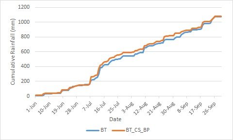
According to Davids et al. (2019), the S4W rain gauge used by citizen scientists for taking rainfall measurements is estimated to have an error of 2.9% compared to a standard Department of Hydrology and Meteorology (DHM) gauge. As an additional evaluation of the citizen scientists’ rainfall data from the S4W rain gauge in comparison to the DHM gauge, the CS stations located near the DHM stations (i.e., co-located stations) were chosen by generating Thiessen polygons in QGIS and identifying polygons with both a DHM gauge and CS station. Then, 17 co-located stations resulting from this process were selected to directly compare with the standard DHM rain gauge in the Valley. Only overlapping data from May to September 2019 were used for statistical comparison. The data of citizen scientists were correlated with the respective DHM stations based on Pearson correlation coefficient method to determine their relationship. The correlation between 10 co-located stations was found to be strong (above 0.60), 5 co-located stations were moderate (between 0.40-0.59), and 2 co-located stations were weak (below 0.39). The correlations for all stations were statistically significant at 0.01 significance level except for two; differences at the two stations may be due to greater distances between DHM and CS stations in these locations (~1.5 km for Sakhnu and ~0.5 km for Naikap). The times series of cumulative rainfall suggests that there is a similar trend of rainfall in both DHM and citizen scientists’ stations (Figure 3).
Figure 3: Time series of cumulative rainfall amount from June to August 2019 of Bhaktapur DHM station (BT) and citizen scientist station (BT_CS_BP)
These results demonstrate that citizen science can be a feasible approach for collecting reliable rainfall data, along with educating the citizen scientists about the need and applications of hydrometeorological data. Also, the simple and cost-effective S4W-Nepal rain gauge is accurate enough to generate reliable rainfall measurement data. Therefore, citizen scientist networks should be further expanded to other regions in Nepal to fulfill the hydro-meteorological data gaps that exist. Furthermore, citizen scientists should be educated, trained, and motivated to complete regular rainfall measurements since these data can have a big impact in the field of research and support better water resource management decisions, along with raising awareness with citizens about the complexity and value of managing this precious resource.
References
Davids, J. C., Devkota, N., Pandey, A., Prajapati, R., Ertis, B. A., Rutten, M. M., Lyon, S. W, Bogaard, T. A. and Giesen, N. V. (2019) Soda Bottle Science—Citizen Science Monsoon Precipitation Monitoring in Nepal. Frontiers in Earth Science [online]. 7. Available from DOI: 10.3389/feart.2019.00046.
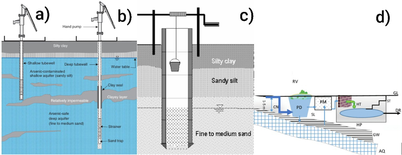
Groundwater, the water present in the spaces between rock and soil particles of the saturated zone underneath the earth’s surface, is a major source of freshwater for sustaining both global human civilizations and ecosystems (Earman and Dettinger, 2011). In the Kathmandu Valley of Nepal (Valley), groundwater is widely used for various purposes, including drinking and agriculture. The major sources of groundwater in the Valley include dug wells, tube wells, stone spouts, and deep tube wells (Figure 1).
Figure 1: Schematic diagram of different sources of groundwater a) shallow tube well, b) deep tubewell, c) dug well and d) stone spout: RV = Reservoir, CN = Canal (Rajkulo), PD = Pond, FM = Filtration media, SL= Supply line, HT = Hiti, HP = Hiti platform, DR= Drainage (overflow), GW = Groundwater, AQ = Aquifer (confined), GL = Ground level, ST = Stairs (Ahmed, 2002; Ahuja et al., 2014; Ghimire and Johnston, 2015)
More than 50% of the water demand of the Valley is supplied by the groundwater (Aryal, 2011; Shrestha, 2017), and approximately 60 Million-Litres-a-day (MLD) of the total municipal water supply is extracted from various groundwater resources (Dhakal, 2010). Additionally, mechanized groundwater extraction is widespread in the Valley due to the uneven distribution of water resources in the Valley, an inadequate municipal water supply, and other factors. Overall, the groundwater extraction rate is six times higher than its natural recharge capacity, resulting in the groundwater table being lowered by approximately 2.5 meters per year (Shrestha, 2009). This extensive extraction of groundwater in the Valley is a result of diverse anthropogenic activities and demands regular monitoring of groundwater levels.
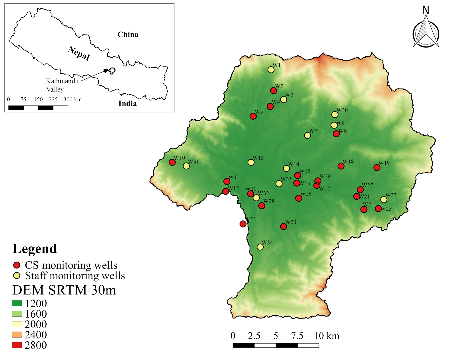
Therefore, Smartphones For Water Nepal (S4W-Nepal) started monitoring groundwater levels in the Valley in 2017 through a citizen science approach. Citizen science engages the general public in the scientific research design, data collection, analysis, and other scientific works in collaboration with professional scientists (Cappa et al., 2018). Also, it increases the scientific knowledge of the local people or Citizen Scientists (CS), in this example with regards to groundwater level fluctuations. We at S4W-Nepal intend to continue to monitor groundwater levels and expand our data’s spatial coverage by following this feasible and sustainable approach. In order to monitor groundwater levels, we have selected certain existing wells in the Valley, considering their spatial location and distribution. Figure 2 shows the location of regular monitoring wells of S4W-Nepal, including both CS and staff sites. Unlike other water resources monitoring projects, S4W-Nepal promotes sustainable monitoring of groundwater resources by converting the existing wells into monitoring wells and involving CS in collecting groundwater level data. In the middle of every month, our citizen scientists record the groundwater level with a measuring tape and an android application called Open Data Kit (ODK) Collect. The CS can easily record the date and time of data collection, location of monitoring well, and the depth to water in meters (along with photos taken on site) through a customized form developed by S4W-Nepal in ODK Collect and forward it to the server of S4W-Nepal. Once data are received, we perform quality control and do immediate follow-up calls to minimize errors.
S4W-Nepal’s Citizen Scientists for monitoring groundwater level
We recruit most of our CS through a variety of outreach programs, social media, and personal contacts. There is no age, gender, and educational restriction to become a CS; anyone interested in the scientific process of data collection can become a CS. To date, S4W-Nepal has recruited and trained 86 CS to monitor groundwater levels. Understanding groundwater level variation and supporting the sustainable management of groundwater resources motivates our CS to collect the data regularly. The age of CS involved in S4W-Nepal for monitoring gw level data ranges between 15 – 33 years, and the majority of them are students from different educational backgrounds. Out of our 86 CS, 40 (46.5%) are female and 46 (53.5%) are male. We currently have 23 regular CS collecting monthly groundwater level data from different locations of the Valley. We regularly communicate with our CS through follow up calls/SMS with monthly reminders or follow-up on data collection, to see if they have any questions, and to encourage them to continue data collection and their involvement. One of the challenges of citizen science projects is maintaining and seeking to improve the engagement of CS over time.
Temporal variation of groundwater levels in the Valley
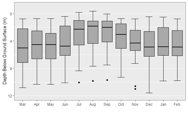
Based on the groundwater level data collected by our CS from March of 2019 to February of 2020, a preliminary analysis has been done to understand the temporal variation of groundwater levels of the Valley (Figure 3). Data from 35 regular monitoring wells have been taken into consideration in this analysis.
The boxplot below reveals the monthly fluctuations of groundwater in the time period of 1 year. The groundwater level is maximum during the monsoon season (June- September), and the groundwater level is lowest in December of 2019 (i.e., post-monsoon period). Also, the groundwater levels dropped sharply from October of 2019, the beginning of the post-monsoon period. This indicates the direct influence of rainfall on the groundwater level.
Figure 3: Boxplot showing the monthly groundwater level fluctuation
Despite the critical need for groundwater monitoring, there is still a significant data gap that needs to be closed to better understand groundwater fluctuations across the Valley and under varying conditions. Therefore, the regular monitoring of the groundwater level by using a citizen science approach should be continued and expanded. Besides, it will make the general public more aware of groundwater conditions, more actively involved in monitoring and managing this critical resource, and will promote proper groundwater resources management.
Ahuja, S., Larsen, M. C., Eimers, J. L., Patterson, C. L., Sengupta, S. and Schnoor, J. L. (2014) Comprehensive water quality and purification. Waltham, MA: Elsevier.
Aryal, R. S. (2011). Ground water reality.New Spotlight. 4(19). March 25, 2011.
Cappa, F., Laut, J., Porfiri, M. and Giustiniano, L. (2018) Bring them aboard: Rewarding participation in technology-mediated citizen science projects. Computers in Human Behavior [online]. 89, pp.246-257. Available from DOI: 10.1016/j.chb.2018.08.017
Earman, S. and Dettinger, M. (2011) Potential impacts of climate change on groundwater resources – a global review. Journal of Water and Climate Change [online]. 2(4), pp. 213–229. Available from DOI: 10.2166/wcc.2011.034
Ghimire, S. and Johnston, J,M. (2015) Traditional Knowledge of Rainwater Harvesting Compared to Five Modern Case Studies. Conference: Environmental and Water Resources Congress 2015 [online]. Available from DOI: 10.1061/9780784479162.017
Shrestha, S. (2017) The contested common pool resource: Ground water use in urban Kathmandu, Nepal. The Geographical Journal of Nepal. 10, pp. 153-166.
Dinesh Pathak Central Department of Geology, Tribhuvan University Kirtipur, Kathmandu, Nepal Email: dpathaktu@gmail.com
Dinesh Pathak Central Department of Geology, Tribhuvan University Kirtipur, Kathmandu, Nepal Email: dpathaktu@gmail.com
Abstract
This article focuses on the water-induced disaster (landslide and flood) conditions in Nepal. It analyzesThe past and present water-induced disaster conditions in the country haves been analyzed, the importance and means for creation of the database have been explored, identifies data gaps in water induced-disaster mitigation have been identified, explores the importance and means for creation of a database to house and organize data, visualizes the role of citizen scientists in data generation was visualized, and describes the efforts to date of S4W-Nepal there have been signified and described.
Introduction
The Himalayan region represents an active tectonic zone, and about 35% of the Himalayan belt lies in Nepal. The 147,515 km2 territory of Nepal can be divided into three main geographical regions; the Himalayan region covers 15% of the total area, the hilly region covers 68%, and Terai, also known as the food basket of the country covers 17% of the total area. The Himalayan terrain is formed by the complex geological process, which is still continuing to shape the Himalayan region. Such geological activities together with the hydrometeorological process have caused various types of hazards that eventually pose vulnerability to people, infrastructure, and natural resources. Thus, the larger population in the region has been exposed to multi-hazards, like earthquakes, landslides, soil degradation, flood, deforestation, loss of biodiversity, and drought.
Water-borne disasters like landslides, floods, soil erosion are common during the monsoon period in the entire Himalayan region. Snow avalanches are common, and glacial lake outbursts occasionally occur in the Himalayan region. These disasters have a significant impact on the natural system, settlements, and infrastructure in Nepal. In the past decades, climate change has been observed worldwide. For the future, predictions indicate average temperature rise, change in precipitation patterns in space and time, melting glaciers, sea-level rise, etc. with a large band of uncertainty. Likewise, extreme drought, intense rainfall, severe flood events, etc. are also predicted to occur more often under climate change conditions.
Different aspects of disasters like a landslide, dam outburst flood, the occurrence of landslides due to bank erosion by the river and slope instability, floods, and infrastructure failure causing landslides and floods, etc. are different sorts of water-induced disasters. Himalaya is extremely vulnerable to natural disasters due to its geology, steep slopes, high relief, and monsoon climates and among the different natural disasters, landslides are important geological events in many parts of the world (Pathak, 2016a).
Effect of past water induced disaster in the country
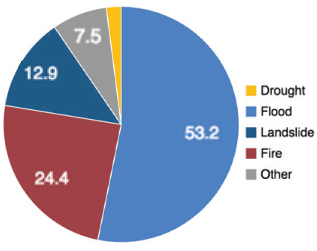
Water induced disasters (Landslide and flood disaster) have greater and regular impacts among all other disasters, which is evident from the highest mortality (66%) for the period between 1990 and 2014 (Figure 1).
Figure 1: Disaster mortality in Nepal between 1990 and 2014 (UNISDR, 2015)
Several events of water-induced disasters have increased the number of deaths, displacement of large numbers of families with damages to thousands of houses. It is quite convincing that these disasters are the major disasters in the country with an eminent impact on the people. Nevertheless, the earthquake disaster has a much greater and long term impact on all sectors of life even though it happens in a longer time interval. Even a single earthquake event can have more death, destruction of houses and infrastructure, as well as greater economic losses than the total due to other disasters in several decades.
The water induced disaster
Landslide and debris flow
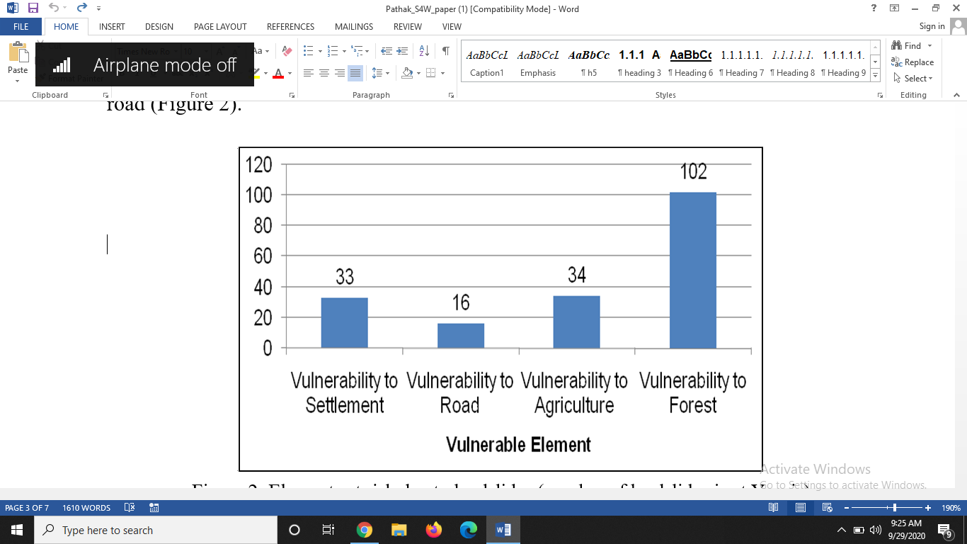
Landslides are common in all physiographic regions of Nepal, i.e. from the Chure range in the south to the Higher Himalayan region in the north. The analysis of landslide data in different regions of Nepal shows that in general, most of the landslides have occurred in elevation class between 500 m and 2000 m. Physiographically, landslide occurrence is more in Middle Mountain and High Mountain regions. Likewise, the topographic slope is another important factor for the occurrence of landslides, and the slope angle between 20 and 40 degrees is most sensitive for the landslide occurrence. Geologically, most slope instability issues are in Siwalik and Lesser Himalayan regions. Generally, we believe that the vegetation-covered areas are the stable ground; in contrast, the analysis of the data shows that in most of the cases, landslides occur in the forest area. It indicates that the vegetation is effective to provide ground stability only against the shallow slope failure, while for the deep-seated failure plane, especially below the root zone of the vegetation, large scale landslides may occur with significant damages to the forest land that may impose risks to other elements like settlement, agriculture land, and infrastructure at the downslope. An analysis of landslide vulnerability in eastern Nepal shows that many landslides have increased vulnerability to forest followed by agriculture, settlement, and road (Figure 2).
Figure 2: Elements at risk due to landslides (number of landslides is at Y-axis)
Google Earth’s image is useful for the rapid assessment of landslides in an area, and it is especially useful in the identification of large and disastrous landslides (Figure 3). Likewise, it is quite helpful to identify the earthquake-induced landslides through comparison between the images before and after an earthquake (Figure 4). Either a new landslide can be developed or the old inactive landslide could be triggered during an earthquake.
Figure 3: Landslide in (a) Okhaldhunga district located at Manebhanjyang Gaupalika; and (b) Sankhuwasabha district at Makalu Gaupalika
Figure 4: Damage to road from earthquake due to triggering of the old landslide as well as the development of a new landslide in Dhading (left image before the earthquake and right image after the earthquake)
Flood
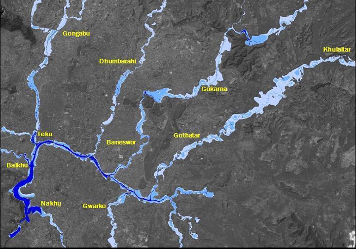
Flood is a common hazard that sometimes becomes a disastrous event due to its magnitude and presence of a large number of vulnerable elements. Such events are occurring both in the mountainous regions as well as in the Plain area. The rivers flowing through the Kathmandu valley have been heavily stressed due to encroachment as a result of urbanization. The natural regimes of the rivers are not maintained to the required waterway and also the natural regime of the river is much affected. This is the reason that many regions in the Kathmandu Valley are experiencing flood problems in each monsoon period. The flood hazard map of the Kathmandu Valley shows that both the urban core areas, as well as newly urbanized areas are prone to flood problems (Figure 5).
Figure 5: Flood hazard map of Kathmandu Valley. The deeper blue color shows deeper water level (Pathak et al., 2009).
Gaps in water induced disaster mitigation
In order to address the growing vulnerability due to the water-induced disaster, proper understanding of the biophysical, social, and institutional components is required. The water-induced disaster mitigation (WIDM) has been given the prime importance from the government of Nepal, however, a mounting disaster-induced loss indicates that disaster risk reduction is far from getting its due share of attention and resources (Pathak 2016b). Lack of seriousness and accountability of the decision-making authority, unavailability of the adequate database, low priority, and insufficient fund allocation for the disaster related study are some of the issues related to the inefficiency of disaster mitigation. Pathak (2016c) has pointed out some of the important measures to be considered for effective water-induced disaster management, which are listed below:
A hazard map is not adequate for planning rather risk map is more useful
A comprehensive disaster database will be supportive for disaster management
Prioritization of the watershed based on the water-induced disaster will facilitate effective disaster management
Regular monitoring and effective early warning system will reduce disaster loss
Institutional strengthening with effective coordination and networking among government line agencies
I/NGO should be given appropriate roles to work in coordination with the government in a supportive role. These organizations should work on various sectors as identified and prioritized by the government
Get prepared for the worst
Conclusion
Landslide and debris flow, as well as floods, are the major water-induced disasters in Nepal. There are many stakeholders for effective disaster management, namely government, non-government organization, disaster experts as well as the local residents. The role and activities of those stakeholders are almost defined, however, the role of local residents is least brought to the mainstream of disaster management. Data required for disaster management are available on national, provincial, and district level. However, there is a scarcity of data (like precipitation and flood discharge) at the local level, especially at the community level. These data are required to assess the disaster condition and to develop models required for disaster management. The local residents can be trained and given the responsibility to measure the hydrometeorological data so that a comprehensive database can be formed at the community level. Besides, these citizen scientists can act as valuable messengers to the community regarding community awareness in disaster management. S4W-Nepal has realised the importance of citizen science and its activities are focused to bridge the gap.
References
Pathak D, 2016a. Knowledge based landslide susceptibility mapping in the Himalayas. Geoenvironmental Disasters (2016) 3:8, DOI 10.1186/s40677-016-0042-0
Pathak D, 2016b. Water Induced Disaster Mitigation from Watershed Management Perspective in Nepal – An Example from Dobhan Khola Watershed, West Nepal. International journal of landslide and environment, vol. 4(1-3), 9-19.
Pathak D, 2016c. Water induced disaster mitigation in Nepal – present approach and way forward for effective water induced disaster mitigation from geological perspective. Disaster Review 2015, pp. 25-30.
Pathak D, Gajurel AP, Dwivedi SK, Shreshta GB, 2009. Flood risk mapping in urban area using high resolution satellite imageries. Proceedings of international seminar on hazard management for sustainable development, 29-30 Nov, 2009, Kathmandu, Nepal, (organized by Department of Water Induced Disaster Prevention, Nepal Engineering College and Ehime University). Eds. H.K. Shrestha, R. Yatabe and N.P. Bhandary, pp. 233-244.
UNISDR, 2015. Global Assessment Report on Disaster Risk Reduction 2015: Nepal. UNISDR Note: ‘Young Researcher’Issue 3 – Sept 2020


 one spouts.